Derek Hayes
book reviews:
· general fiction
· chick lit/romance
· sci-fi/fantasy
· graphic novels
· nonfiction
· audio books
· author interviews
· children's books @
curledupkids.com
· DVD reviews @
curledupdvd.com
newsletter
win books
buy online
links
home
for authors
& publishers
for reviewers
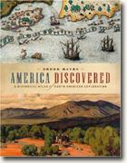 |
America Discovered: A Historical Atlas of Exploration Derek Hayes Douglas & McIntyre Hardcover 224 pages November 2004 |
|
A map is the best example of the thousand-word picture. Historical maps speak volumes, laying out not only the vision, oftimes limited, of their creators, but the future – of roads, of economic expansion in all directions, of the development of towns and cities from forts and crossings.
But this book is not merely maps – the text is extensive and scholarly. Consider the story behind Map Number 178 – in width, seven feet, it was drawn up to impress the governor of Quebec and secure a monopoly in fur trade for the Hudson Bay Company in the region of Canada known as the Athabasca. “They did not get their monopoly, but history got their map.” It’s coming on Christmas, and yes, Virginia, it’s time to be hunting up gifts for that over-curious nephew or melancholic father-in-law. This book could be just the thing. My copy goes to my history-loving, map-collecting hubby. Pricey, but worth the money for its full-color panoramas and wealth of detail. Happy holidays, and thank you, Mr. Hayes! © 2004 by Barbara Bamberger Scott for curledup.com. |
 Derek Hayes, a geographer, researcher and collector of maps, has made our American development both the stuff of map geek’s dreams and a feast for the creative imagination. Beginning with the first, and arguably fake, map of Gronlandia, and ending with a spectacular LANDSAT satellite image of the northeastern coastline, the book leaves no doubt as to the impact of technology on the accuracy of the mapmaker’s art. For art was more a factor in early maps; the ocean’s waves, people and trees out of scale on colorful lumps of land, and other spatial distortions were all that served to guide the intrepid earliest explorers, who then were set the task of improving the work as they went along. Some of these became what Hayes calls “artistically superb and geographically absurd,” such as that published by a French cartographer in 1762, in which Louisiana jingoistically occupies almost the whole of what would become the territory of the United States and a giant sea clots most of southwest Canada. Very often the extremes of these old maps were labeled “Parts Unknown,” a true anachronism in the world we now live in, where, perhaps lamentably, all parts are known.
|
|
|
 Click here to learn more about this month's sponsor! |
|
| fiction · sf/f · comic books · nonfiction · audio newsletter · free book contest · buy books online review index · links · · authors & publishers reviewers |
|
| site by ELBO Computing Resources, Inc. | |
